
The Char Dham Yatra is one of India's most sacred religious pilgrimages. It takes devotees through the magnificent Garhwal Himalayas of Uttarakhand. The journey connects four sacred pilgrimage sites: Yamunotri, Gangotri, Kedarnath, and Badrinath, located in the remote Himalayan mountains and accessible via a network of well-maintained roads. Knowing the route map of Char Dham is also essential, as it helps pilgrims plan their travel dates, choose transportation options like Rajasthan Cab, manage weather acclimatization, and have a safe and enjoyable journey.
The pilgrimage typically begins in Haridwar or Rishikesh, the entry points to the Himalayas, and follows a clockwise direction, a direction that is believed to be spiritually favourable. It is a mixture of road and walking, traversing the valleys of rivers, towns, and cities on the hills and in high mountain areas. A thorough understanding of the route map will enable pilgrims to prepare physically and logistically for this holy journey.
Char Dham Yatra Route Map from Haridwar and Rishikesh
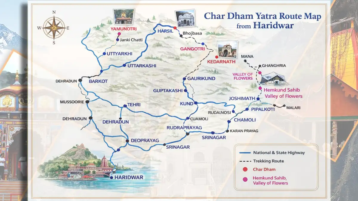
Typically, pilgrims start their journey at either Haridwar or Rishikesh, both of which have excellent rail and road connections to major Indian cities. Haridwar is selected due to its religious significance, whereas Rishikesh provides convenient transport connections to the hills.
Out of these towns, pilgrims enter the Garhwal Himalayan area. These starting points are the best for acclimatisation because the route increases in altitude steadily. Char Dham Registration is normally done at this point by pilgrims. At Rishikesh, it splits off to Barkot, Uttarkashi, Guptkashi, and Joshimath, which is the main part of the Char Dham route map.
Below is the table for the Char Dham Yatra Route Map from Delhi/Haridwar/Rishikesh:
| Stop No. | Route / Destination | Major Halt / Town | Travel Mode |
|---|---|---|---|
| 1 | Delhi/Haridwar/Rishikesh | Haridwar | Starting point of Char Dham Yatra |
| 2 | Haridwar/Rishikesh → Barkot | Barkot | Base for Yamunotri |
| 3 | Barkot → Yamunotri | Janki Chatti | The trek starts from Janki Chatti |
| 4 | Yamunotri → Uttarkashi | Uttarkashi | Drive back after darshan |
| 5 | Uttarkashi → Gangotri | Harsil | Scenic drive via Harsil |
| 6 | Gangotri → Guptkashi | Guptkashi | Long drive, overnight halt |
| 7 | Guptkashi → Kedarnath | Gaurikund | Trek/helicopter to Kedarnath |
| 8 | Kedarnath → Rudraprayag | Rudraprayag | Return journey |
| 9 | Rudraprayag → Joshimath | Joshimath | Base for Badrinath |
| 10 | Joshimath → Badrinath | Badrinath | Final Char Dham |
| 11 | Badrinath → Haridwar | Via Joshimath & Rudraprayag | Return route |
Yamunotri Dham Yatra Route Map: The First Sacred Destination
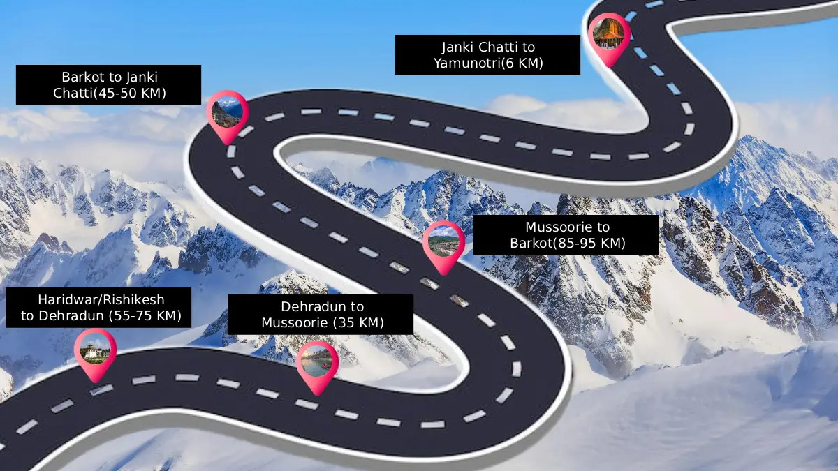
The first place in the traditional Char Dham series is Yamunotri, the birthplace of the River Yamuna. Pilgrims go by road, via Haridwar or Rishikesh, to Barkot, where they pass picturesque towns, including Mussoorie and Nainbagh. The road goes on to Janki Chatti, the furthest motorable location, at Barkot. There, a 6-kilometer walk will take one to the Yamunotri Temple. The pilgrimage is sufficiently signposted and attended by ponies, palanquins, and refreshment stands. The pilgrimage route indicates steep ascents, narrow roads, and elevated areas, and thus proper planning is critical, particularly among the aged pilgrims.
Below is the table for the Yamunotri Dham Yatra Route Map from Delhi/Haridwar/Rishikesh:
| Step | Route | Distance (Approx.) | Travel Mode |
|---|---|---|---|
| 1 | Delhi / Haridwar / Rishikesh → Dehradun | 55-75 km | Road journey |
| 2 | Dehradun → Mussoorie | 30-35 km | Hill drive |
| 3 | Mussoorie → Barkot | 95-100 km | Via Kempty Falls |
| 4 | Barkot → Janki Chatti | 40-45 km | Road journey |
| 5 | Janki Chatti → Yamunotri | 5-6 km | Trek / Pony / Palki |
Gangotri Dham Yatra Route Map: Following the Bhagirathi River
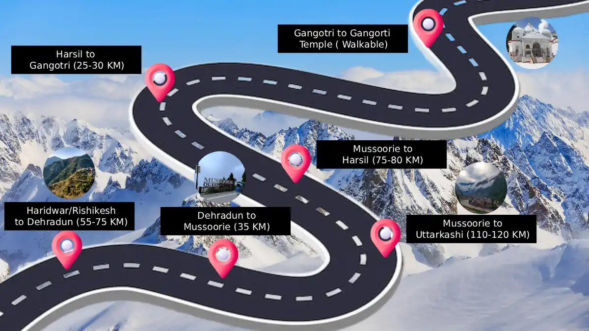
The route after Yamunotri turns back to Barkot and goes towards Uttarkashi, a big destination on the Char Dham circuit. The road goes along the Bhagirathi River, which is one of the Himalayan valleys, and the view is fantastic as you travel through Uttarkashi. The trip to Gangotri, the origin of the River Ganga, is wholly motorable. The pilgrims cross Gangnani, which has hot-water springs and then reach Gangotri temple town. According to the route map, the Gangotri leg is not as challenging as other dhams, but even weather and altitude require good planning.
Below is the table for the Gangotri Dham Yatra Route Map from Delhi/Haridwar/Rishikesh:
| Step | Route Segment | Approx. Distance | Travel Mode |
|---|---|---|---|
| 1 | Delhi / Haridwar / Rishikesh → Dehradun | 55–75 km | NH road, smooth start |
| 2 | Dehradun → Mussoorie | 30-35 km | Hill drive |
| 3 | Mussoorie → Uttarkashi | 110-120 km | Via Kempty / scenic stretches |
| 4 | Uttarkashi → Harsil | 75-80 km | Bhagirathi River views |
| 5 | Harsil → Gangotri | 25-30 km | Final road stretch |
| 6 | Gangotri → Gangotri Temple | Walkable | Temple area access |
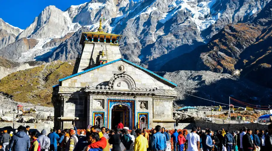
Kedarnath Dham Yatra Route Map: The Most Challenging Segment
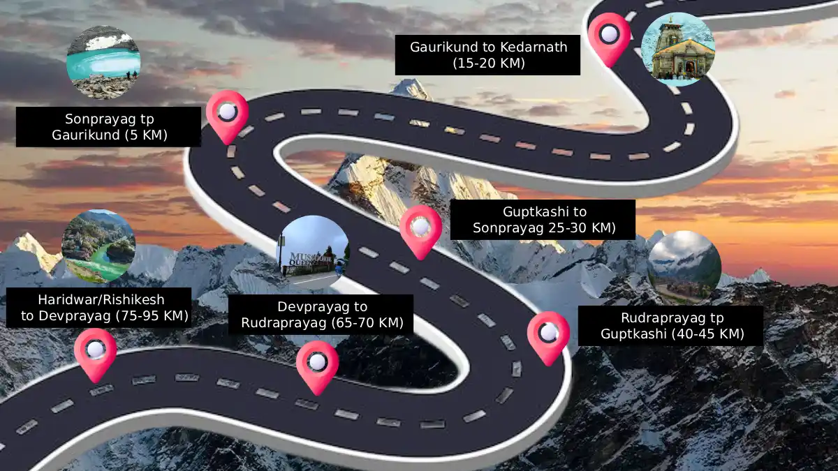
The path to Kedarnath is regarded as the most challenging in the Char Dham Yatra. The pilgrims begin at Uttarkashi and proceed back to Guptkashi or Sonprayag through Rudraprayag and picturesque confluences of Himalayan rivers.
The last road station is Sonprayag. At that point, pilgrims arrive at the base camp of the trek, Gaurikund. The Kedarnath Temple is an 18 km uphill stroll that demands body and mind. This stretch is considered a high-risk area due to altitude, unpredictable weather, and steep terrain, as indicated in the route map. The pilgrims who are unable to walk can use ponies, palanquins, or helicopters. There are medical aid posts and shelters at frequent intervals.
Below is the table for the Kedarnath Dham Yatra Route Map from Delhi/Haridwar/Rishikesh:
| Step | Route Segment | Approx. Distance | Travel Mode |
|---|---|---|---|
| 1 | Delhi / Haridwar / Rishikesh → Devprayag | 75–95 km | Road journey |
| 2 | Devprayag → Rudraprayag | 65-70 km | Along the Alaknanda River |
| 3 | Rudraprayag → Guptkashi | 40-45 km | Hill drive |
| 4 | Guptkashi → Sonprayag | 25-30 km | Mountain roads |
| 5 | Sonprayag → Gaurikund | 5 km | Local shuttle |
| 6 | Gaurikund → Kedarnath | 15-20 km | Trek / Pony / Palki / Helicopter |
Badrinath Dham Yatra Route Map: The Final Destination
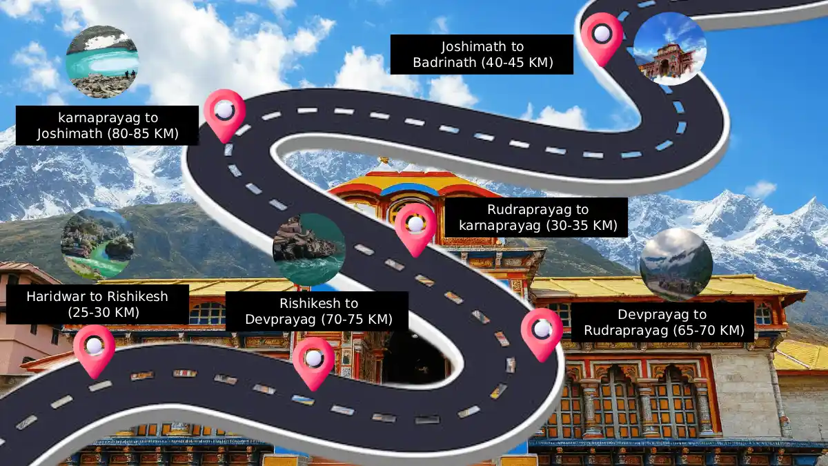
Once the Kedarnath visit is complete, the pilgrims visit the last dham of Badrinath. It has a road that goes through Joshimath, which is one of the major rest and transit towns. The road goes on to Badrinath Temple, on the Alaknanda River, at Joshimath. This is a motorable road and has panoramic views of snow-clad mountains. It is not as demanding as Kedarnath but still requires carefulness due to landslide-prone areas and narrow mountain roads. This is the terminus of the route map of the Char Dham Yatra, which represents the end of the pilgrimage.
Below is the table for the Badrinath Dham Yatra Route Map from Delhi/Haridwar/Rishikesh:
| Step | Route Segment | Approx. Distance | Notes |
|---|---|---|---|
| 1 | Delhi/Haridwar → Rishikesh | 25-30 km | NH road |
| 2 | Rishikesh → Devprayag | 70-75 km | Bhagirathi–Alaknanda Sangam |
| 3 | Devprayag → Rudraprayag | 65-70 km | Mountain drive |
| 4 | Rudraprayag → Karnaprayag | 30-35 km | Via NH-7 |
| 5 | Karnaprayag → Joshimath | 80-85 km | Long hill stretch |
| 6 | Joshimath → Badrinath | 40-45 km | Final ascent |
Char Dham Related Tour Packages
Best Order and Distance Overview of the Char Dham Route
The route sequence that is traditionally followed is Yamunotri → Gangotri → Kedarnath → Badrinath.
Approximate distances:
-
Haridwar to Yamunotri: 220 km (plus trek)
-
Yamunotri to Gangotri: 230km.
-
Gangotri to Kedarnath: 280km (plus trek)
-
Kedarnath to Badrinath: 215 Km
-
Badrinath to Haridwar: 320km.
This is a clockwise path that will enable a more effective acclimatization and smooth movement of travel among the altitudes.
Highlights of the Char Dham Yatra Route Map
-
Starts at Haridwar or Rishikesh, the gateways to the Himalayas.
-
Takes a clockwise, spiritually meaningful path.
-
Combines walking paths and road trails.
-
Crosses major stopping towns such as Barkot, Uttarkashi, Guptkashi, and Joshimath.
-
Kedarnath entails the most difficult and lengthy walk.
-
Badrinath is well-connected and motorable.
-
The path provides breathtaking scenery of snow peaks, rivers, and valleys.
-
Medical assistance, shelters, and transportation services are provided in strategic stretches.